Increasingly, the climate change debate is part of the dialogue surrounding catastrophic weather events, including floods, fires and severe weather impacting Canada. Emerging research is focusing on how climate change may be impacting extreme weather events, and the insurance industry is grappling with how to respond to a changing landscape of risk. Set on a backdrop of normal climate variability through natural cycles, the impacts are also complicated by the complexity of the interaction between the ocean and atmosphere, and the arctic and mid-latitudes. These teleconnections make it difficult to separate the signal from the noise. The biggest question of all is whether the future will resemble the past.
An interesting starting point for all weather is in the arctic, and scientists are beginning to focus on the connections between the arctic and weather in the middle latitudes, especially in North America. The term “arctic amplification” refers to the idea that the arctic is warming faster than anywhere else on the earth, and that the current warming accelerates future warming in a positive feedback loop. Scientists often cite the shrinking extent of arctic sea ice as the primary driver of the warming. As sea ice extent shrinks, the warm ocean surface is exposed to air, which has several implications. A white ice surface reflects incoming solar radiation back to space, keeping the surface colder. Conversely, a darker ocean surface absorbs incoming solar radiation, warming the ocean surface and also warming the lower levels of the atmosphere. A warmer atmosphere can hold more water vapor, which is an important greenhouse gas. So as arctic sea ice extent shrinks, the arctic atmosphere continues to warm more rapidly through these complimentary processes.

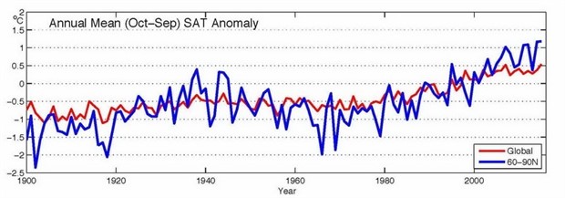
Figure 1: Arctic (land stations north of 60°N) and global mean annual land surface air temperature (SAT) anomalies (in °C) for the period 1900-2015 relative to the 1981-2010 mean value (CRUTEM4 dataset)
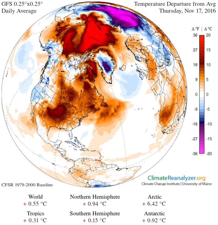
Observations certainly support the theory that arctic amplification is leading to greater warming in the arctic than the warming being observed in the global average. There has been an ~3 degree Celsius warming in the arctic since the beginning of the 20th century. Seasonal anomalies have been quite profound. Arctic sea ice extent reaches an annual minimum at the end of September each year. At that point, the on-set of the arctic night triggers a freezing up of the sea. However, for the past decade or so, this freezing up has been delayed due to anomalously warm temperatures in the late fall and early winter. In November of 2016, temperatures were 20 degrees Celsius warmer than the daily average, and this coincided with a record low coverage of arctic sea ice.

Figure 2: Daily temperature anomalies on Nov 17, 2016 when record high temperatures coincided with record low sea ice extent (ClimateReanalyzer.org)
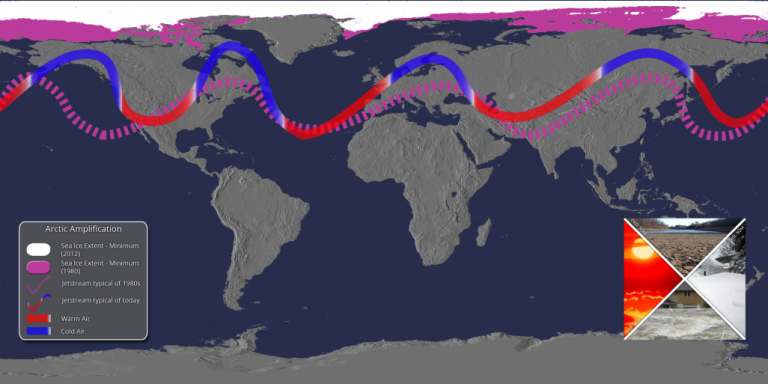
Research indicates that another positive feedback cycle is emerging; namely that when the Arctic is very warm, it is leading to the jet stream taking wavier paths—big northward swings and southward dips. The jet stream is driven by temperature differences between the poles and the tropics. Scientists have observed that the reduced temperature difference between the North Pole and tropics is associated with slower west-to-east jet stream movement and a greater north-south dip in its path. The poleward branch of this pronounced jet stream transports heat and moisture from deeper in the tropics north into the Arctic, which heats the Arctic more.

Figure 3: Schematic of typical 1980’s sea ice extent and jet stream pattern (purple), contrasting with current artic sea ice extent (white) and the jet stream pattern of today (reds and blues) (SSEC at University of Wisconsin)
The real question is: how does this warming of the arctic affect weather in the middle latitudes, including North America? The answer may lie in the physics and dynamics of a slower and wavier jet stream. This pattern causes a “stickiness” in the typical progression of storms. Rather than moving along quickly, systems are beginning to stall and intensify, resulting in more extreme weather, including floods, large hail, and severe drought accelerating wildfires.
This type of ‘sticky’ jet stream pattern was in place during the on-set of the Fort McMurray wildfire. A dome of persistent high pressure was in place over Northern Alberta for several weeks preceding the event, causing abnormally warm temperatures and a lack of precipitation that directly contributed to ample fuel for a large and damaging wildfire. On the flip side of the coin, when stuck in the rainy part of the jet stream, extreme precipitation is possible. A study completed at the Prairie Climate Center in 2017 projected spring precipitation in the mid-century to be 40-50% higher than the baseline in some locations in Southern Alberta and Saskatchewan, resulting in the potential for massive flash flooding along the many rivers of the Prairie Provinces.
While observations and theory suggest that arctic amplification is already occurring and is going to be difficult to reverse, the actual impacts to communities in the northern hemisphere are still greatly uncertain. As outlined above, there is an active research community endeavoring to shed light on the various potential impacts, including extreme weather that has the potential to change the landscape of risk in Canada. Our existing tools rely heavily on the idea that the future will resemble the past; it is, therefore, imperative that the insurance industry continue to develop innovative approaches to managing risk, and partner with the academic community to better understand the problem and customize solutions.
